The Chronologue Celestial Coordinate System
Intended audience
This is an example of the Concept template, which is an Explanation document in the Diataxis documentation system.
Intended audience: Scientists familiar with coordinate systems who don’t understand the Chronologue’s coordinate system, and want to know how it maps to data structures. Software developers who need to know how the coordinate system works and what the data structures represent. Hobbyists who are curious about how the Chronologue coordinate system works.
Astronomical coordinate systems are used for specifying positions of celestial objects relative to a given reference frame, based on physical reference points available to a situated observer. The Chronologue Celestial Coordinate system (CCCS) is an astronomical coordinate system used exclusively by the Chronologue. As the Chronologue can “hop” from one point to another, the CCCS was developed to describe navigation that uses a series of directions rather than a single direction with a static starting point.
The CCCS is similar to a travel itinerary. It describes a destination point, a period of time spent at the destination point, and then describes another destination point. This repeats until the final destination is reached.
Once the Chronologue has deployed a miniature wormhole within the gravitational influence of an object, the wormhole will exist in a relative position to the object and can be traced backwards and forwards through time.
The basis of the CCCS is that any object at any point in time can be used as the origin of a new vector pointing to another object.
Background
Existing astronomical coordinate systems use the Earth (geocentric) or the Sun (heliocentric) as the origin point and indicate a specific direction to a specific object. This does not function appropriately for the Chronologue as the Chronologue is capable of viewing objects at any time, including events that predate or postdate the existence of the Earth or the Sun.
Traditionally an astronomical coordinate system is used to describe the location of specific astronomical objects within a specific context. Using a specific origin point, an astronomical coordinate system uses a center point, a fundamental plane, and direction to indicate the location of an object.
The design of these astronomical coordinate systems are based on the original use cases of these systems. Historically, astronomical coordinate systems were used in astronomy to define the locations of astronomical objects. Even with significant investment in spacefaring technology, the Earth remains the origin point for nearly all space missions, or destinations can be plotted using existing coordinate systems in series. This makes a complex coordinate system like CCCS unnecessary for any practical use outside of the context of the Chronologue.
Use cases
The CCCS is fundamental to the operation of Octavia’s Chronologue. Without the CCCS, the Chronologue would not be able to view objects more than one “hop” away from the Chronologue.
Examples
Consider the following example, where the Chronologue is navigating to Object C:
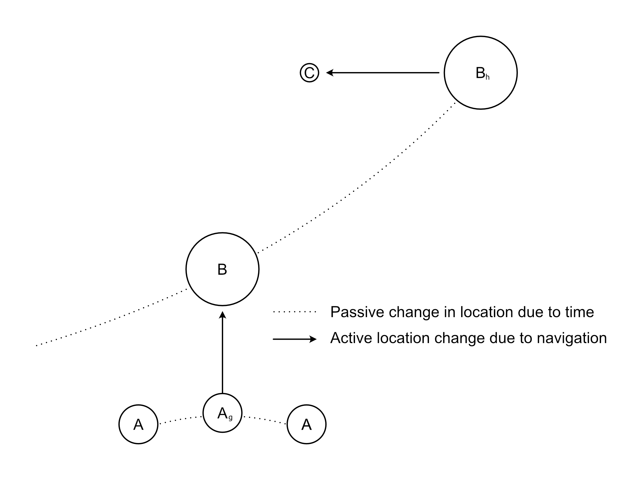
To find Object C using the CCCS:
At
time_t(g)a set of coordinates (x1andy1) are followed from Object A (the Earth) to find Object B.The Chronologue’s wormhole stays in proximity to Object B while time passes.
After a specific amount of time passes (
time_rp(h)), a new set of coordinates (x2andy2) are followed to find Object C.
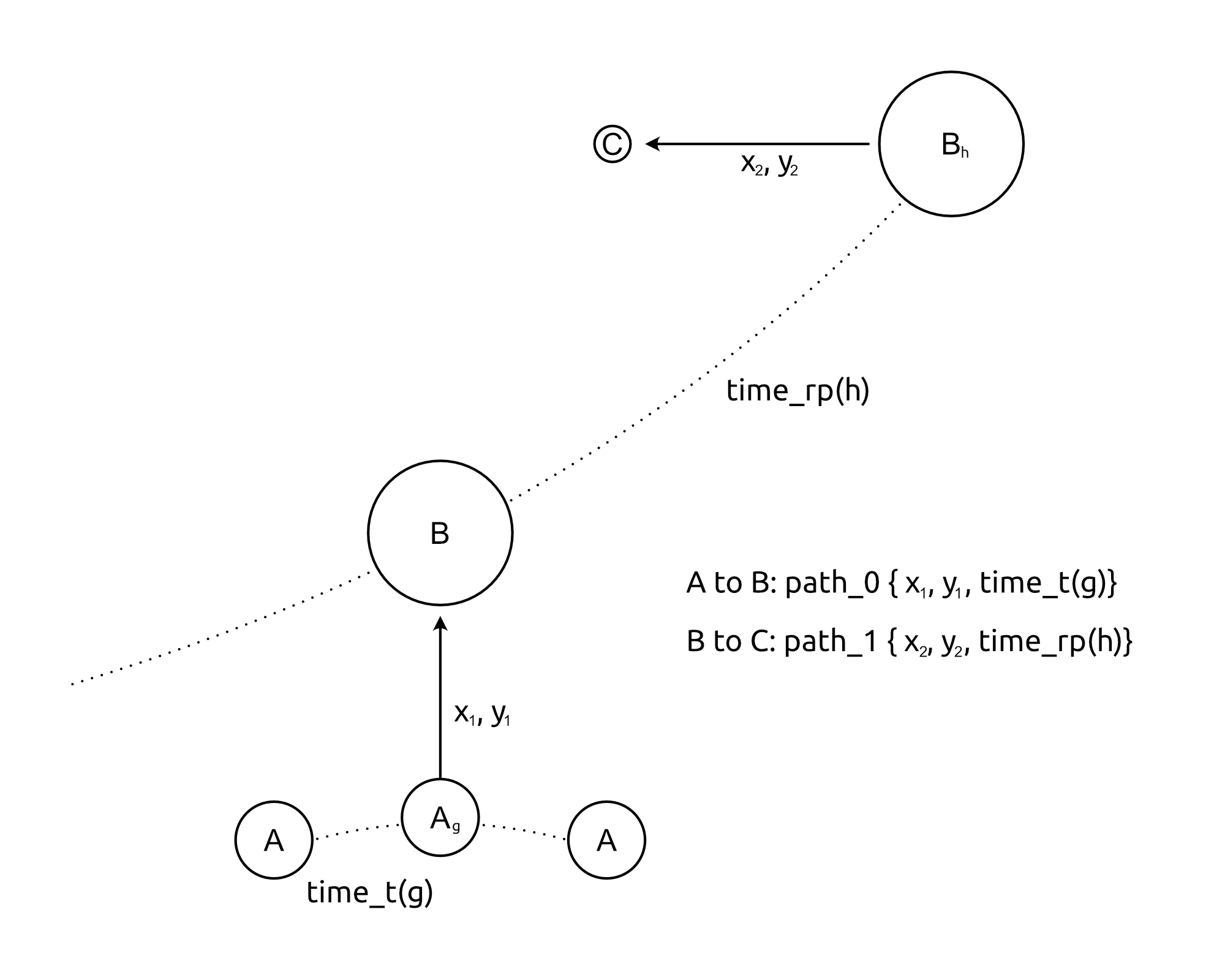
To represent this in a data structure used by the Chronologue’s API:
{
    "name": "Object B",
    "location":  {
        "path_0": {"x": "x1", "y": "y1", "distance": "r_prox", "time_r": "g"},
    }

    "name": "Object C",
    "location":  {
        "path_0": {"x": "x1", "y": "y1", "distance": "r_prox", "time_r": "g"},
        "path_1": {"x": "x2", "y": "y2", "distance": "r_prox", "time_r": "h"}
    }
}
Comparison to other astronomical coordinate systems
Coordinate system |
Center point (origin) |
Fundamental plane (0° latitude) |
Poles |
Latitude |
Longitude |
Primary direction (0° longitude) |
|---|---|---|---|---|---|---|
Horizontal (also called alt-az or el-az) |
Observer |
Altitude (a) or elevation |
Azimuth (A) |
|||
Declination (δ) |
Right ascension (α) or hour angle (h) |
|||||
Center of the Sun |
Galactic latitude (b) |
Galactic longitude (l) |
||||
Supergalactic poles |
Supergalactic latitude (SGB) |
Supergalactic longitude (SGL) |
Intersection of supergalactic plane and galactic plane |
|||
Chronologue Celestial Coordinate System |
Center of the Earth, the relative position around another body |
Declination (δ) |
Right ascension (α) or hour angle (h) |
March equinox or origin direction |
Major differences
The most significant difference between the CCCS and other coordinate systems is time, and the lack of a fixed origin point for any vector after the first.